Flat-Earth-distance (Плоскозёмное расстояние) 제작자: Mike Osincev
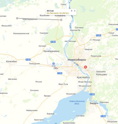
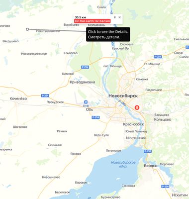
Converts distance on Yandex map to the distance on a Flat Earth. Производит расчёт расстояния для плоской земли на Яндекс.карте. Используйте инструмент "Линейка".
사용자 1명사용자 1명
확장 메타 데이터
스크린샷
정보
Объяснение расчётов
A,B,C - стороны прямоугольного треугольника.
A - от Северного полюса до Точки.
B - от Точки до Нулевого меридиана (под углом 90°).
C - от пересечения B и Нулевого меридиана до Северного полюса.
X и Y - координаты на виртуальной "карте Мира" (азимутальная проекция) размером 40000 км, нулевая отметка в верхнем левом углу.
Если "x,y" координаты Северного полюса "20000,20000", X и Y Точки расчитываются исходя из их положения относительно Северного полюса.
Вычитая X и Y двух Точек, получаем треугольник, гипотенуза которого является расстоянием между Точками.
Explanation of the calculations
A,B,C are the sides of a right triangle.
A - from the North Pole to the Point.
B - from the Point to the Prime Meridian (at an 90° angle).
C - from the intersection of B and the Prime Meridian to the North Pole.
X and Y - coordinates on the virtual "world map" (azimuthal projection) with the size of 40,000 km, the zero mark in the upper-left corner.
If the "x,y" coordinates of the North Pole are "20000,20000", the X and Y of the Points are calculated based on their position relative to the North Pole.
Subtracting the X and Y of the two points, we get a triangle whose hypotenuse is the distance between the points.
0명이 0점으로 평가함
권한 및 데이터
추가 정보
- 부가 기능 링크
- 버전
- 1.3
- 크기
- 46.37 KB
- 마지막 업데이트
- 4년 전 (2022년 9월 21일)
- 관련 카테고리
- 버전 목록
- 모음집에 추가